What if one tide change could make your Eliot riverfront home look like two different properties? If you are preparing to sell, you want images that capture the best version of your shoreline and views. With a little timing, you can showcase calm reflections, reveal useful details, and keep everyone safe. This guide shows you how to plan tides, light, season and access for standout photos along the Piscataqua. Let’s dive in.
Eliot’s tidal riverfront
Eliot sits on the tidal Piscataqua River near Portsmouth Harbor, where currents are among the strongest in New England. The current reverses with each tide, which changes surface texture, safety near docks, and how boats move in your frame. For precise timing, check local NOAA station pages for Portsmouth and Seavey Island before you schedule a shoot. Start with the NOAA Tides and Currents station reference for Portsmouth Harbor.
The Eliot Boat Basin is a convenient public vantage point for scouting angles and community shots. Follow posted rules and consider calling the town before staging gear on site. You can review passes and seasonal notes on the Town of Eliot Boat Launch page.
Tide timing shapes your images
The same property reads very differently at high, low, and slack tide. Plan your look first, then match the tide.
High tide reflections
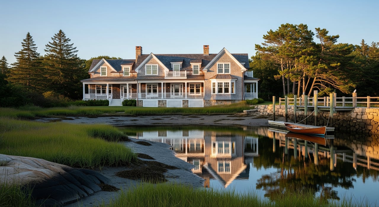
- High tide brings water close to vegetation and docks. You get fewer exposed mudflats and cleaner mirror reflections.
- This timing helps homes feel more connected to the water and hides exposed pilings or erosion scars.
- Pair high tide with golden hour for warm light and glassy looks. Confirm the day’s tide height and time with NOAA predictions for the local datum.
Low tide detail
- Low tide exposes ledges, rocks and mudflats. It is the moment to document dock footings, seawalls, stairs, and intertidal conditions.
- Use it to show beach extent or the grade of the lot. Allow extra time to walk to revealed ledges.
- Low tide can reveal hazards that buyers need to see. Build a short disclosure set while you are there.
Slack current moments
- The Piscataqua’s swift currents create ripples and streaks that break up reflections. Around slack tide, the current is weakest and water can read calmer.
- Slack does not always line up with peak high or low. Review current behavior for Portsmouth Harbor in the NOAA technical overview of the estuary and plan accordingly.
Plan sun, season and weather
Great waterfront photos come from aligning light with your chosen tide window.
Golden hour plus tide
- Use a sun-planning app to see exactly where the sun will rise or set relative to the facade you want to feature. Tools like The Photographer’s Ephemeris help you line up the best angles.
- For glowing reflections, target golden hour near high tide. For clean, honest detail sets, low tide with soft morning light works well.
Seasonal looks to expect
- Summer brings long days, lush greenery and occasional marine haze. Evenings often deliver warmer light and calmer water.
- Fall color typically peaks in mid to late October in southern Maine. Time exteriors with the state foliage outlook to add color around the frame.
- Winter can be dramatic with snow and ice, but daylight is short and conditions are cold. Plan tight shot lists.
- Fog is possible on cool mornings. Check local wind and visibility on the National Weather Service forecast page before you head out.
Smart locations and access
Respect for property lines and shoreline rules keeps your shoot smooth and neighborly.
Public vantage points
- Use the Eliot Boat Basin for wide context and community images. Follow posted hours and launch policies posted by the town.
- If you need a boat-based angle, confirm ramp usability and parking before you go. The state maintains a list of public boat launches and ramp details.
Permissions and shoreland rules
- Always get owner permission before stepping onto private docks or shorelines. Do not assume access from the water.
- Maine’s shoreland zoning controls activity close to the high-water line. Review state guidance and check with local code enforcement for any gray areas using Maine DEP shoreland zoning resources.
Drone and water safety
Aerials and riverside work add impact when they are done safely and legally.
Drone basics
- Any commercial drone shoot must follow FAA small UAS rules. Confirm your pilot’s Part 107 status and check airspace and local park policies. See the FAA Part 107 overview for requirements.
- Launch only from spots that allow it and obtain owner permission for takeoff and landing. Avoid flight over people not involved in the operation.
River safety
- Currents on the Piscataqua are strong and shift with the tide. Treat docks, small boats and exposed banks with caution.
- Build in extra time at slack tide, wear life jackets when near or on the water, and avoid unstable or eroding edges. The NOAA estuary brief notes the area’s fast-moving water.
Your pre-shoot checklist
- Pull NOAA tide times and heights for your exact date at Portsmouth or Seavey Island.
- Map sun angles and golden-hour windows with The Photographer’s Ephemeris.
- Check NWS wind, precipitation and visibility for your time block.
- Confirm all access permissions, including dock, shoreline and any drone work.
- Prep gear for both high and low tide sets. Pack safety essentials.
Shot list that sells the waterfront
- Exterior hero: whole house with river foreground, scheduled for golden hour near high tide.
- Context wide: property, vegetation, dock and shoreline at mid to high tide.
- Dock and seawall details: close-ups of pilings, ladders and stairs at low tide.
- Shoreline and beach: low-tide frames that show extent, grade and intertidal textures.
- Aerial overview: parcel outline, shoreline contour and dock location, with permissions and FAA compliance.
- Interior toward water: balanced exposures that hold the view while keeping rooms bright.
- Safety set: erosion, riprap and stairs documented for clarity and disclosure.
Ready to put this timing to work for your Eliot listing? Our team plans tide, light and access so your riverfront shows its best. For thoughtful marketing and broker-led guidance, reach out to Great Seacoast Homes.
FAQs
When should I schedule photos to get mirror-like water in Eliot?
- Aim for golden hour close to a high tide, then confirm exact times with NOAA’s local station data.
How do tides change what buyers see in riverfront photos?
- High tide softens shorelines and boosts reflections, while low tide reveals beaches, ledges and dock footings that help buyers understand the property.
Can I use a drone to photograph my Piscataqua River property?
- Yes if you comply with FAA Part 107 rules, get owner permission for launch and landing, and follow any town or park policies.
Where can I legally photograph the river in Eliot without entering private land?
- The Eliot Boat Basin is a common public vantage point; follow posted rules and consider contacting the town about any commercial activity.
When does fall foliage usually peak for colorful riverfront shots?
- Southern Maine typically reaches peak to near-peak color in mid to late October according to the state foliage outlook.